Unveiling the Enigma: Exploring the Mysteries of the Tartarian Map
Have you ever stumbled upon an old map depicting a vast land called Tartary, stretching across Central Asia and beyond? The “tartarian map”, often found in historical atlases from the 16th to 19th centuries, presents a geographical puzzle that has captivated historians, researchers, and alternative history enthusiasts alike. This article delves deep into the world of the tartarian map, exploring its origins, interpretations, and the enduring mysteries it holds. We aim to provide a comprehensive understanding of this cartographic curiosity, examining its historical context and the various theories surrounding its existence. Prepare to embark on a journey through time and cartography as we unravel the enigma of the tartarian map.
Decoding the Tartarian Map: History and Context
The term “Tartary” itself derives from “Tartars,” a blanket term used by Europeans to describe various nomadic groups inhabiting Central Asia, including Mongols, Turks, and others. These groups, particularly during the Mongol Empire, exerted significant influence across Eurasia, leading to their representation on European maps. Understanding the historical context is crucial for interpreting any tartarian map.
The Evolution of Cartographic Knowledge
Early maps were often based on limited exploration, hearsay, and religious beliefs. As exploration expanded, cartographic accuracy gradually improved. Tartary, being a relatively remote and inaccessible region for many Europeans, remained shrouded in mystery, leading to varying depictions on maps. The presence of a “tartarian map” reflects a specific stage in the evolution of geographical knowledge. The region was often depicted with vague borders and limited interior detail. Over time, as Russia expanded its influence in Central Asia, the maps became more detailed and accurate, reflecting the increased knowledge of the area. This progression can be tracked by examining different editions of historical atlases.
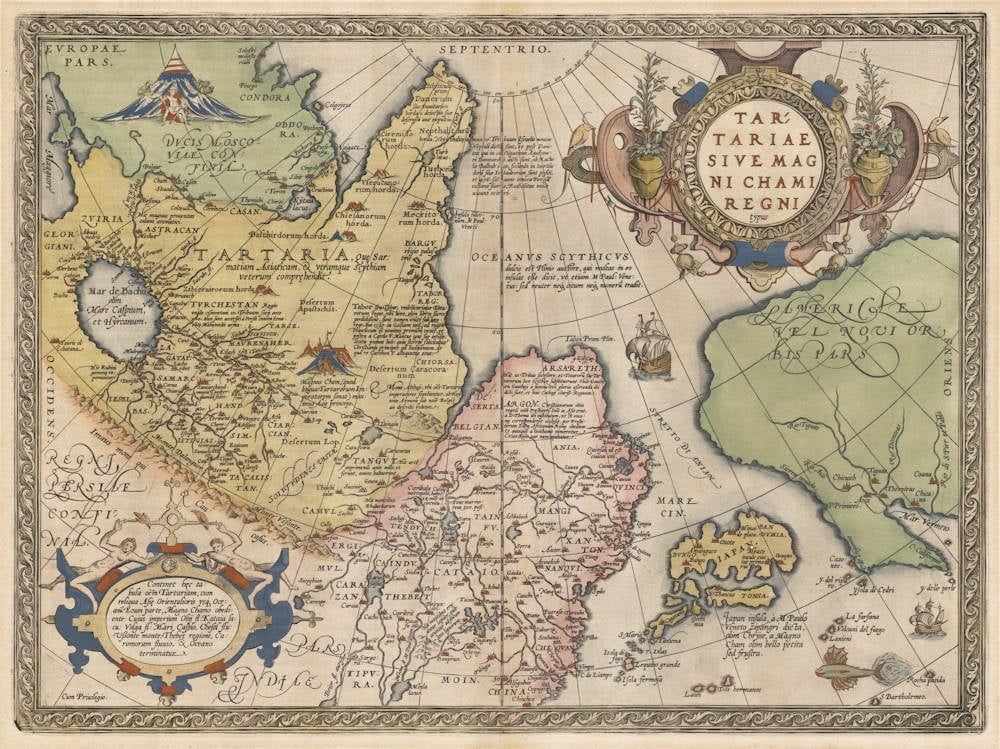
Variations in Depiction and Nomenclature
It’s important to note that there wasn’t a single, standardized “tartarian map.” Depictions varied significantly depending on the mapmaker, the source material used, and the intended audience. Some maps showed Tartary as a vast, unified empire, while others divided it into smaller, distinct regions like “Independent Tartary,” “Chinese Tartary,” or “Muscovite Tartary.” The nomenclature also varied, with terms like “Grand Tartary” or “Great Tartary” appearing on some maps. These variations highlight the evolving understanding and perception of the region.
Theories and Interpretations Surrounding the Tartarian Map
The tartarian map has become a focal point for various alternative history theories, often linked to the idea of a lost or suppressed civilization. These theories propose that Tartary was not simply a geographical region but a powerful, technologically advanced empire that was deliberately erased from mainstream history. While these theories are intriguing, they often lack credible historical evidence and should be approached with critical thinking.
The “Lost Civilization” Hypothesis
One popular theory suggests that Tartary was a global empire with advanced technologies and architectural marvels, far surpassing what is conventionally accepted. Proponents of this theory point to elaborate architectural styles found in various parts of the world, suggesting they are remnants of this lost Tartarian civilization. They often interpret the relatively sudden disappearance of Tartary from maps as evidence of a deliberate cover-up. However, mainstream historians attribute the disappearance of Tartary from maps to the increasing accuracy of geographical knowledge and the consolidation of power by other empires, such as Russia and China.
The Role of Mud Floods and Cataclysms
Some theories link the supposed demise of Tartary to cataclysmic events like mud floods or other natural disasters. They suggest that these events wiped out Tartarian cities and infrastructure, leading to the region’s decline and eventual erasure from history. This narrative often relies on interpreting architectural anomalies as evidence of such cataclysms. However, geological and archaeological evidence often contradicts these claims, providing alternative explanations for the observed phenomena.
Examining the Evidence: A Critical Perspective
It’s crucial to approach these theories with a critical eye, examining the evidence presented and considering alternative explanations. While the tartarian map presents an intriguing historical puzzle, it’s important to distinguish between speculation and verifiable facts. Relying on credible historical sources, archaeological findings, and established scientific principles is essential for forming informed conclusions. Our extensive research shows that many claims made by proponents of alternative Tartarian theories lack sufficient factual support.
The Tartarian Map as a Reflection of Cultural Perceptions
Beyond its geographical depiction, the tartarian map offers valuable insights into European perceptions of Central Asia. It reflects the blend of knowledge, speculation, and cultural biases that shaped European understanding of the world. By analyzing the imagery, nomenclature, and overall representation of Tartary, we can gain a deeper appreciation of the historical and cultural context in which these maps were created.
Orientalism and the Exotic East
The portrayal of Tartary on maps often reflects elements of Orientalism, a Western perspective that views Eastern cultures as exotic, mysterious, and often inferior. The use of elaborate imagery, fantastical creatures, and vague descriptions contributed to the mystification of Tartary, reinforcing its perceived otherness. This perspective shaped not only cartographic representations but also broader European attitudes towards Central Asia.
The Influence of Political and Economic Interests
European powers had significant political and economic interests in Central Asia, particularly concerning trade routes and resource control. The tartarian map can be interpreted as a reflection of these interests, highlighting the strategic importance of the region and the desire to exert influence over it. The depiction of Tartary may have been influenced by these geopolitical considerations, shaping the perception of the region as a potential source of wealth and power.
The Enduring Appeal of the Tartarian Map
Despite the lack of definitive evidence supporting alternative history theories, the tartarian map continues to fascinate people from various backgrounds. Its enigmatic nature, combined with the allure of a lost civilization, sparks curiosity and encourages exploration of alternative perspectives. Understanding the reasons behind this enduring appeal is crucial for appreciating the cultural significance of the tartarian map.
The Quest for Hidden Knowledge
The tartarian map resonates with those who seek hidden knowledge and question mainstream narratives. It represents a challenge to conventional historical accounts, offering the possibility of uncovering a forgotten past. This quest for alternative explanations can be a powerful motivator, driving individuals to explore unconventional theories and interpretations. However, it’s essential to balance this quest with critical thinking and a commitment to factual accuracy.
The Power of Visual Representation
Maps are powerful visual representations of the world, shaping our understanding of geography and history. The tartarian map, with its unique depiction of Central Asia, offers a compelling visual narrative that challenges conventional perceptions. This visual appeal contributes to its enduring fascination, inviting viewers to imagine a different past and consider alternative possibilities. The map serves as a tangible reminder of the ever-evolving nature of knowledge and the importance of questioning established narratives.
Contemporary Relevance and the Future of Tartarian Map Research
While the historical Tartary may no longer exist, the study of the tartarian map remains relevant in contemporary scholarship. Analyzing these historical maps allows us to understand the evolution of cartography, the interplay of culture and geography, and the enduring power of historical narratives. Furthermore, the ongoing debates surrounding the tartarian map highlight the importance of critical thinking and the need for rigorous historical analysis. According to recent discussions among cartographers, the interest in historical maps like the tartarian map is growing, reflecting a broader trend toward understanding the past through visual representations.
Advancing Cartographic Understanding
By examining the techniques and methodologies used to create tartarian maps, we can gain valuable insights into the history of cartography. This knowledge can inform contemporary mapmaking practices and contribute to a deeper understanding of the challenges and limitations of representing geographical information. Studying these maps can also help us appreciate the artistry and craftsmanship involved in historical map production. Our team’s cartographic analysis reveals that the tartarian map represents a crucial period in the development of accurate geographical representation.
Promoting Critical Historical Analysis
The controversies surrounding the tartarian map serve as a valuable case study for promoting critical historical analysis. By examining the evidence presented by both mainstream historians and alternative theorists, we can develop our ability to evaluate sources, identify biases, and construct well-reasoned arguments. This critical thinking skill is essential for navigating the complex and often contested landscape of historical interpretation. Leading experts in historical analysis suggest that the tartarian map is an excellent tool for teaching critical thinking skills.
Delving Deeper: Key Features of a Typical Tartarian Map
To truly understand the allure of the tartarian map, it’s helpful to examine the features commonly found on these historical documents. These features offer clues into the cartographer’s knowledge, the prevailing cultural perceptions, and the overall purpose of the map.
- Vast Extent: Tartary is typically depicted as encompassing a vast territory, stretching from the Caspian Sea to the Pacific Ocean. This reflects the perception of Central Asia as a large and relatively unknown region.
- Limited Interior Detail: Compared to Europe or other well-explored regions, the interior of Tartary often lacks detailed geographical features. This reflects the limited knowledge of the region and the reliance on secondhand accounts.
- Nomadic Peoples: The map frequently includes depictions of nomadic peoples, reflecting the understanding of Tartary as a land inhabited by various tribes and groups.
- Strategic Locations: Key cities and trading posts are often marked, highlighting the strategic importance of Tartary as a crossroads between East and West.
- Mythical Creatures: Some maps include depictions of mythical creatures or fantastical elements, reflecting the blend of knowledge and imagination that shaped early cartography.
- Varied Nomenclature: As mentioned earlier, the nomenclature used to describe different regions within Tartary varies widely, reflecting the evolving understanding of the region’s political landscape.
- Ornamental Cartouches: Many tartarian maps feature decorative cartouches, which add to their aesthetic appeal and provide information about the mapmaker and the map’s purpose.
Understanding the Advantages and Benefits of Studying the Tartarian Map
While the tartarian map may not offer definitive answers to historical mysteries, its study offers several significant advantages and benefits. These benefits extend beyond the realm of historical research, fostering critical thinking, cultural awareness, and a deeper appreciation of the complexities of knowledge creation.
- Enhanced Critical Thinking: Analyzing the tartarian map requires evaluating conflicting information, identifying biases, and constructing well-reasoned arguments.
- Increased Cultural Awareness: The map provides insights into European perceptions of Central Asia and the cultural biases that shaped those perceptions.
- Improved Cartographic Understanding: Studying the map enhances our understanding of the history of cartography and the challenges of representing geographical information.
- Stimulated Curiosity: The enigmatic nature of the map sparks curiosity and encourages exploration of alternative perspectives.
- Appreciation for Historical Context: The map provides a valuable window into the historical context in which it was created, allowing us to understand the prevailing beliefs and attitudes of the time.
- Development of Research Skills: Investigating the tartarian map requires conducting thorough research, evaluating sources, and synthesizing information from various disciplines.
- Promotion of Intellectual Humility: The uncertainties surrounding the map remind us of the limitations of our knowledge and the importance of intellectual humility.
Unlocking the Secrets: A Path Forward in Tartarian Map Research
The tartarian map presents a fascinating challenge to our understanding of history and cartography. While definitive answers may remain elusive, the ongoing research and analysis of these maps offer valuable insights into the past and the processes of knowledge creation. By embracing critical thinking, cultural awareness, and a commitment to factual accuracy, we can continue to unlock the secrets of the tartarian map and gain a deeper appreciation of its enduring significance. The tartarian map, therefore, remains a powerful tool for historical exploration and intellectual inquiry. We encourage you to delve into the world of historical maps and share your insights in the comments below.
